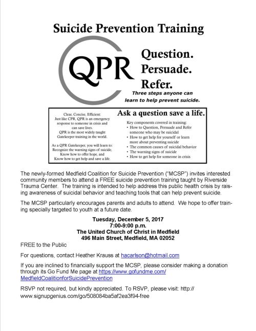
A traffic signal is needed at the Rte. 27 intersection with South Street, because of traffic volumes and backups, per a January 19 letter from traffic engineers hired by Chief Meaney to study the need, summarizing their recent study. The traffic signal is projected to cost about $200,000.
Reportedly, however, Mike Sullivan says Chief Meaney is considering whether to ask the town meeting to proceed with that traffic signal or one for the intersection of Rte. 27 and West Street, which has a high number of accidents, many of which have been serious due the speeds of the vehicles.
The letter appears below and as a more readable PDF is here 20160119-mcmanus-town of medfield_route 27 (spring street) at south street_signal memo (2…
McMAHON ASSOCIATES
300 Myles Standish Boulevard | Suite 201 | Taunton, MA 02780
p 508-823-2245| f 508-823-2246
mcmahon a ssociates.com
PR INCI PA LS
Joseph W. McMahon, P.E. Joseph J. DeSantis, P.E., PTOE
John S. DePalma William T. Steffens Casey A. Moore, P.E.
Gary R. McNaughton, P.E., PTOE
A SSOCIA T ES
John J. Mitchell, P.E. Christopher J. Williams, P.E.
R. Trent Ebersole, P.E. Matthew M. Kozsuch, P.E. Maureen Chlebek, P.E., PTOE
Corporate Headquarters: Fort Washington, Pennsylvania
Serving the East Coast from 13 offices throughout the Mid-Atlantic, New England, and Florida
January 19, 2016
DRAFT
Chief Robert E. Meaney, Jr. Medfield Police Department 110 North Street
Medfield, MA 02052
RE:
Route 27 at South Street ‐ Medfield, MA
Dear Chief Meaney:
McMahon Associates has completed a traffic warrant analysis at the intersection of Route 27 (Spring
Street/High Street) at South Street in Medfield, Massachusetts. The purpose of this study is to
evaluate existing traffic conditions at the intersection and to determine if a traffic signal is
warranted. Our assessment is based on a review of current traffic volumes, accident data, and
anticipated traffic growth over a 10‐year period. This study examines and documents future
conditions under unsignalized and signalized scenarios.
EXISTING CONDITIONS
The study area is composed of the two intersections of Route 27 with South Street, which are offset
intersections approximately 600 feet apart. The study area intersections are displayed in the
attached Figure 1. The southerly intersection of Route 27 (High Street) and South Street is
currently signalized, while the northerly intersection of Route 27 (Spring Street) and South Street
is unsignalized, with free‐flowing traffic on Route 27 and stop control on South Street.
Route 27 (Spring Street/High Street) is a two‐way, two‐lane urban principal arterial under Town of
Medfield jurisdiction. Route 27 is approximately 30 feet in width providing one‐foot wide shoulders
on either side of the roadway and generally runs in the north‐south direction through the Town of
Medfield. Route 27 currently has a posted speed limit of 40 miles an hour in the study area.
Both segments of South Street are two‐lane, two‐way urban minor arterials also under Town of
Medfield jurisdiction, which runs in the east‐west direction through the Town of Medfield. The two
segments of South Streets have shoulder widths varying from one to three feet on either
side, with a posted speed limit of 30 miles an hour in the study area.
Chief Robert E. Meaney
DRAFT
January 19, 2016
Page 2 of 9
Route 27 (High Street) at South Street
At the southerly intersection with South Street, Route 27 (High Street) provides a through lane and
exclusive right turn lane on the southbound approach, and a through lane and exclusive left turn
lane on the northbound approach. South Street is approximately 40 feet in width and provides a
single multi‐use lane on the eastbound approach with shoulder widths ranging from one to three feet
on either side. There is a crosswalk located across the southbound approach at the intersection,
which spans across Route 27 and provides connectivity between the sidewalk on the eastern side of
Route 27 and the northern side of South Street. There is also a raised island present on the
southbound approach to facilitate the channelized right turn lane. The intersection of Route 27
(High Street) at South Street is currently signalized in all directions and provides an exclusive
pedestrian phase.
Route 27 (Spring Street) at South Street
The northerly intersection of Route 27 (Spring Street) at South Street is approximately 25 feet in
width at its intersection with South Street, providing one‐foot shoulders on either side. South
Street is approximately 75 feet wide at its intersection with Route 27 (Spring Street), with no
shoulders on either side of the roadway. South Street is currently under stop control at the
intersection, while Route 27 (Spring Street) is free‐flowing in the north‐south direction. There
are currently no crosswalks present at the intersection of Route 27 (Spring Street) at South
Street. However, there is an existing portion of sidewalk on the southeastern corner of the
intersection which provides connectivity to the intersection of Route 27 (High Street) at South
Street.
Sight Distance
A field review of the available sight distance was conducted at the South Street westbound approach
at the intersection of Route 27 (Spring Street). Route 27 (Spring Street) has a posted speed limit
of 40 miles per hour in both directions. The American Association of State Highway and
Transportation Officials’ (AASHTO) publication, A Policy on Geometric Design, 2011 Edition, defines
minimum and desirable sight distances at intersections. The minimum sight distance is based on the
required stopping sight distance (SSD) for vehicles traveling along the main road and the desirable
sight distance allows vehicles to enter the main street traffic flow without requiring the mainline
traffic to slow to less than 70% of their speed and is referred to as intersection sight distance
(ISD). According to AASHTO, “If the available sight distance for an entering or crossing vehicle is
at least equal to the appropriate stopping sight distance for the major road, then drivers have
sufficient time to anticipate and avoid collisions.” The following table summarizes the sight
distance standards for the various speeds.
Chief Robert E. Meaney
DRAFT
January 19, 2016
Page 3 of 9
Table 1
Sight Distance Requirements
Approach Movement
Speed (MPH)
SSD
Required (ft)
SSD
Measured (ft)
ISD
Required (ft)
ISD
Measured (ft)
Meets Requirements
South Street WB at Route 27 (Spring Street)
Left (South) 40 305 500+ 445 500+
Yes
Right
40 305 500+ 445 500+
Yes
(North)
For the westbound approach of South Street, there is over 500 feet of sight distance in either
direction along Route 27 (Spring Street). Based on the above mentioned requirements for stopping
sight distance and intersection sight distance with a posted speed limit of 40 miles per hour, the
South Street approach at the intersection with Route 27 (Spring Street) provides sufficient
available sight distance.
Existing Traffic Volumes
To assess peak hour traffic conditions, manual turning movement counts were conducted at the study
area intersections on Tuesday, November 10, 2015. The traffic counts were conducted during the
weekday morning peak period from 7:00 AM to 9:00 AM and the weekday afternoon peak period from 4:00
PM to 6:00 PM. The traffic counts are summarized in 15 minute intervals and are attached. The
resulting 2015 unsignalized traffic volumes are shown in Figure 2.
In addition, Automatic Traffic Recorder (ATR) data was collected for a 24‐hour period from Tuesday,
November 10, 2015 through Wednesday, November 11, 2015 on both Route 27 (Spring Street) and South
Street to determine the hourly distributions of traffic for the traffic signal warrant analysis.
MUTCD Signal Warrants
Signal warrant analyses were performed for the unsignalized intersection based on procedures
outlined in the latest edition of the Manual on Uniform Traffic Control Devices (MUTCD). The MUTCD
establishes nine criteria, referred to as warrants, for the installation of traffic signals. The
manual states that satisfaction of these warrants does not in itself require the installation of a
traffic signal. However, a traffic signal should not be installed unless one or more of the
warrants are met. The analyses performed for this report are based on the criteria for the eight‐
hour, four‐hour, and peak hour volume warrants, as well as the pedestrian volume and crash
experience warrants.
Chief Robert E. Meaney
DRAFT
January 19, 2016
Page 4 of 9
Eight‐hour, four‐hour and peak hour signal warrant analyses were performed using existing traffic
volumes at the intersection of Route 27 (Spring Street) and South Street. The results of the signal
warrant analyses are attached, and a summary of the results are presented below in Table 2.
Table 2: Signal Warrant Summary
Intersection Eight‐Hour Four‐Hour Peak Hour Pedestrian
Route 27 (Spring Street)
Crash Experience
at South Street Yes Yes Yes
No No
As seen in Table 2, the intersection of Route 27 (Spring Street) at South Street meets the peak
hour, four hour traffic signal warrants (Warrant 2 and 3), and the eight‐hour traffic signal
warrant (Warrant 1), but does not meet the pedestrian warrant (Warrant 4), or crash experience
warrant (Warrant 7).
For the eight‐hour vehicular volume signal warrant (Warrant 1) to be met, minimum vehicular volumes
for the major street and minor street, found in Table 4C‐1 of the MUTCD, must be exceeded for one
of two volume conditions. Per MUTCD methodology, the 70% factor lowering the volume thresholds
required for satisfying the warrants is applicable to this intersection because of the 40 mph
posted speed limit. A summary of the results of the eight‐hour warrant are presented below in Table
3.
Chief Robert E. Meaney
DRAFT
January 19, 2016
Page 5 of 9
Table 3: Eight‐Hour (Warrant 1) Signal Warrant Summary
Hour
Northbound Volume
Southbound Volume
Existing 2015 Total Major Street Volume
Minor Street Volume
Condition 1 Met1
Condition 2 Met2
6:00 AM 819 306 1125
33 no no
7:00 AM 1388 640 2028
143 yes yes
8:00 AM 1100 588 1688
132 yes yes
9:00 AM 649 501 1150
99 no yes
10:00 AM 485 421 906
111 yes yes
11:00 AM 469 512 981
141 yes yes
12:00 PM 486 475 961
142 yes yes
1:00 PM 488 487 975
137 yes yes
2:00 PM 593 773 1366
279 yes yes
3:00 PM 581 934 1515
302 yes yes
4:00 PM 674 1007 1681
276 yes yes
5:00 PM 702 1010 1712
218 yes yes
6:00 PM 581 882 1463
215 yes yes
7:00 PM 369 452 821
130 yes yes
1 Ma jor street volume greater than 350 vehicles pe r hour and minor street volume greater than 105
vehicles pe r hour. 2 Ma jor street volumes greater than 525 vehicles pe r hour and minor street
volume greater than 53 vehicles pe r hour.
****Spe ed Limit is 40 mph on Route 27 (Spring Street)
As seen in Table 3, both Conditions 1 and 2 of the eight‐hour signal warrant were satisfied during
ten consecutive hours, which surpasses the necessary eight‐hour signal warrant requirements. Based
on the results of the eight‐hour signal warrant and MUTCD criteria, the installation of a traffic
signal at the intersection is warranted. In addition, the results of four‐ hour and peak hour
warrants also support the installation of a traffic signal at the intersection.
Accident Summary
Crash data for the study area intersection was obtained from the Massachusetts Department of
Transportation (MassDOT) for the most recent three‐year period available. This data includes
complete yearly crash summaries for 2011, 2012, and 2013. A summary of the crash data is attached.
The signalized intersection of Route 27 (High Street) at South Street had a total of 11 crashes
reported over the three‐year period from 2011‐2013, resulting in a crash rate of 0.44 crashes per
million entering vehicles at the intersection. This value is lower than the average crash rates of
0.80 and 0.89 for signalized intersections statewide and in MassDOT District 3, respectively. It
should also be noted that the majority of the crashes were rear‐end type crashes resulting in
property damage, which are typical at a signalized intersection.
Chief Robert E. Meaney
DRAFT
January 19, 2016
Page 6 of 9
The unsignalized intersection of Route 27 (Spring Street) at South Street had a total of nine
crashes reported over the three‐year period from 2011‐2013, resulting in a crash rate of 0.37
crashes per million entering vehicles. This is lower than both the statewide and MassDOT District 3
averages for unsignalized intersections of 0.60 and 0.66 crashes per million entering vehicles,
respectively. The majority of the crashes that occurred at the intersection were angle or rear‐end
collisions; however, there were two crashes that were head‐on collisions. All of the reported
crashes resulted in property damage and there do not appear to be any trends related to weather or
time of day.
BACKGROUND TRAFFIC GROWTH
A background growth rate of one percent per year was identified in order to forecast increases in
traffic volumes on the study area roadways and intersections for our future analyses based on
information provided by the Town of Medfield. This rate captures growth associated with general
changes in population and accounts for other small developments in the vicinity of the study area
and is consistent with similar traffic studies completed in this area in recent years. No
additional developments or other roadway projects were identified to be included in the future
traffic analysis. The resulting 2025 Unsignalized traffic volumes are shown in Figure 3 for the
weekday morning and weekday afternoon.
TRAFFIC OPERATIONS ANALYSIS
As a basis for this assessment, intersection capacity analyses were conducted using Synchro
capacity analysis software for the study area intersection under the 2015 Existing, 2025
Unsignalized, and 2025 Signalized conditions. The analysis was based on procedures contained in the
Highway Capacity Manual (HCM). Capacity analysis summaries are attached. A discussion of the
evaluation criteria and a summary of the results of the capacity analyses are presented below.
Level‐of‐Service Criteria
Operating levels of service (LOS) are reported on a scale of A to F with A representing the best
conditions (with little or no delay) and F representing the worst operating conditions (long
delays). In an urbanized area, LOS D is typically considered adequate.
Capacity Analysis Results
Intersection capacity analyses were conducted for the study area intersections to evaluate the 2015
Existing conditions, as well as 2025 Unsignalized, and 2025 Signalized peak hour traffic
conditions. Based on our analysis, the peak hour of the adjacent street traffic occurs between 7:15
AM and 8:15 AM for the weekday morning, and 4:45 PM and 5:45 PM for the weekday afternoon peak
periods. The results of the capacity analyses are presented in Tables 4 and 5 below for the morning
and afternoon peaks, respectively.
Chief Robert E. Meaney
DRAFT
January 19, 2016
Page 7 of 9
Table 4: Morning Level of Service Summary
2015 Existing 2025 Unsignalized
2025 Signalized
Intersection
Movement
LOS1 Delay2 V/C3 LOS1 Delay2 V/C3 LOS1 Delay2 V/C3
Route 27 (High Street) EB L F 155.9 1.28 F 213.6
1.41 F 81.8 1.06
at South Street R A 3.8 0.12 A
0.1 0.05 A 0.6 0.05
NB L B 10.2 0.14 B 10.6 0.16 E 76.9
0.56
T F 227.1 1.44 F 293.1 1.59 F 271.9 1.51
SB T C 33.4 0.92 D 53.7 1.02 F 67.8
0.96
R A 0.1 0.10 A 0.1 0.11 A 0.8 0.11
Overall
F 134.1 1.44 F 179.4 1.59 F 148.1 1.51
Route 27 (Spring Street) WB L F 1175.1 3.24 F 2097.3 5.17
D 39.0 0.68
at South Street R D 28.3 0.11 D
34.7 0.15 B 11.4 0.09
NB TR A 0.0 0.00 A 0.0 0.00 A 11.8
0.78
SB LT C 18.2 0.06 C 21.2 0.08 A 8.1
0.64
1 Level‐of‐Service
Overall
B 10.3 0.78
2 Average vehicle delay in seconds 3 Volume to capacity ratio
n/a Not Applicable
Chief Robert E. Meaney
DRAFT
January 19, 2016
Page 8 of 9
Table 5: Afternoon Level of Service Summary
2015 Existing 2025 Unsignalized
2025 Signalized
Intersection
Movement LOS1 Delay2 V/C3 LOS1 Delay2 V/C3 LOS1 Delay2 V/C3
Route 27 (High Street) EB L B 12.2 0.36 B 12.5
0.39 E 79.0 0.75
at South Street R A 0.0 0.02 A
0.0 0.02 A 0.7 0.02
NB L B 10.8 0.31 B 11.8 0.34 B 10.4 0.20
T C 34.8 0.94 E 61.3 1.05 B 14.3 0.61
SB T B 15.8 0.75 C 20.6 0.83 B 13.6
0.48
R A 0.4 0.30 A 0.5 0.33 A 1.2 0.34
Overall
B 18.1 0.94 C 28.6 1.05 B 15.6 0.75
Route 27 (Spring Street) WB L F 1250.2 3.53 F 2116.2 5.39
F 94.1 1.04
at South Street R C 15.7 0.05 C 17.2
0.07 B 15.2 0.08
NB TR A 0.0 0.00 A 0.0 0.00 A 6.7
0.57
SB LT B 10.2 0.02 B 10.7 0.03 B 16.1 0.86
1 Level‐of‐Service
Overall
C 21.0 1.04
2 Average vehicle delay in seconds 3 Volume to capacity ratio
n/a Not Applicable
As seen in Tables 4 and 5, the proposed signal at the intersection of Route 27 (Spring Street) at
South Street is expected to operate at an overall LOS B during the weekday morning peak hour and at
overall LOS C during the weekday afternoon peak hour. During the weekday morning peak hour, the
westbound and southbound movements are expected to improve in operations compared to the future
unsignalized condition, based on the level of service. During the weekday afternoon peak hour, the
westbound right and southbound movements are expected to improve compared to the future
unsignalized condition, based on level of service. The implementation of a signal at the
intersection will potentially improve the operations of the South Street westbound approach. In
addition, the potential implementation of a dedicated northbound right turn lane on the Route 27
(South Street) approach, as shown in Figure 4, is expected to improve operations at the
intersection. The implementation of a traffic signal in combination with northbound right turn lane
modifications on Route 27 (Spring Street/South Street) would potentially involve Right‐of‐Way
impacts.
RECOMMENDATIONS
Based on the MUTCD traffic signal warrants, accident data, and sight distance measurements, it is
recommended that a two‐phase actuated traffic signal be installed at the intersection of Route
27 (Spring Street) at South Street. A traffic signal will provide significant operational
improvements to the South Street westbound approach while maintaining adequate operations for Route
27 (Spring Street/South Street). A traffic signal concept plan for the intersection of
Chief Robert E. Meaney
DRAFT
January 19, 2016
Page 9 of 9
Route 27 (Spring Street) at South Street is shown in Figure 4. The preliminary construction cost to
install a signal at this intersection is approximately $200,000. This estimate does not include
costs related to potential roadway widening on the eastern side of the northbound approach on Route
27 (South Street), which will allow for more efficient traffic operations at the intersection. In
addition, the potential right‐of‐way or land acquisition costs have not been accounted for in this
estimate.
CONCLUSION
Based on the existing traffic volumes, accident history, and signal warrant analysis, it is
recommended that an actuated and coordinated traffic signal be installed at the intersection of
Route 27 (Spring Street) at South Street. The signal warrant analysis concludes that the
intersection volumes adequately satisfy the peak hour, four‐hour, and eight‐hour warrant
requirements. The capacity analysis indicates that signalizing the intersection will minimize
delay, and allow the intersection to operate at a LOS B and C during the weekday morning and
weekday afternoon peak hours. Under the future unsignalized conditions, motorists on South Street
will continue to experience long delays in the LOS F range during both peak hours. By installing a
signal, these motorists will experience much more acceptable levels of service.
We trust that our review and recommendations have provided you with the appropriate technical
information to finalize a decision on this request. Please do not hesitate to contact me should you
require any further information.
Very truly yours,
Phil Viveiros, P.E., PTOE Project Manager
Attachments
Figure 1 – Study Area Map
Figure 2 – 2015 Existing Weekday Peak Hour Volumes Figure 3 – 2025 Future Weekday Peak Hour Volumes
Figure 4 – Traffic Signal Concept Plan
Traffic Count Data Signal Warrant Backup
Synchro Analysis Reports